Hafran Forest
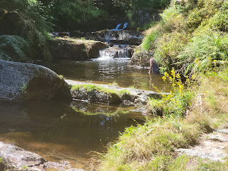
This walk is in two halves. The first is as pretty a walk as you will ever find. The second has THE SWIMMING HOLE. (the caps are warranted.)
Severn-Break-Its -Neck Section Distance: 2 mile loop. Dirt trail and Dirt road, not wheelchair. Well marked with Yellow trail markers. (Note on my map there are two extra bridges to head back if you need to not complete the whole route.) I am not sure if it is dog friendly, as I was busy wrangling kids. Toilets at the parking/trailhead.
Boardwalk Section Distance out and back: .75 miles. Paved and Boardwalk. Wheelchair extra friendly. Dogs OK. Benches and picnic tables. Wear your bathing suit or be prepared to duck behind a tree.
 The map posted at the car park. The first half of the walk is the yellow dots, the second half is the red dots.
Parking Coordinates 52.468709687731035, -3.6841756726984416 In typical Welsh fashion, finding "there" is difficult. The people in the UK use mapping and navigation systems totally not understandable by most Americans. I've spent a great deal of time trying to figure out the key words (and spelling) to help you find this place, but every time I feel like I got it, Google Maps failed. Find the place at the coordinates by leaving Llanidloes on Short Bridge Road. Lots of typical lovely mid Welsh stuff on the way, including Old Hall. The drive in it self is worth the trip.
Head down from the car park. At the bottom of the hill is a ford that will tempt you to take off your boots and wade in the Hafran. Don't do it. You will never leave, and there is a delightful walk ahead of you.
Turn left, almost a u-turn. You will be walking alongside the Hafran on a gravel path. That is the Welsh name for the Severn River further down stream.
At the staircase, head up the stairs. Make note of the bridge that goes off to the right. You may want to cross it later.
Now that there is not the desperate need for fast building material, the managed forests are removing the pine as it comes up, favoring instead the Fir and deciduous trees. The Wiki on this is really informative.
The path meanders above the Hafran, thru stands of blueberries (yum). and comes down to a dirt road that has two concrete bridges. Make note of these should you need to take a short cut back to the parking to deal with cranky kids.
The best bit is as you leave the road. Follow the yellow signs to Severn-Break-Its-Neck or as the Welsh call it Blaen Hafren Falls. The water tumbles over the raw slate.Head back up stream on the other side. You will end up again on the dirt road. Mull on the river's name as you walk. Named by the Romans for the goddess Sabrina. Anglicized to Severn. The Welsh already had a name for it: Hafran.
As you re enter the forest, veer off to the right, following the yellow signs, down the hill. When you get to the bridge (remember I said remember this bridge) you will want to make a decision. Stay to the left if your shoes are easy to remove, or can get wet. Cross the bridge and continue up the river if you want to keep your feet dry.
Boardwalk Section
When you get back too the ford (or if you decide to skip the waterfall hike) walk upstream on the boardwalk. I think this may be the nicest wheelchair access walk I have found as yet in my travels. There are benches and pull outs. All very comfortable.
On the left is the Hafran. At the time we walked it, it was being fed from the Clywedog Reservoir. Down the Severn, the drought is causing problems, so keeping the water flowing is so important.
As you approach the end of the boardwalk, you will see places where peoople duck behind trees to change clothes. Make notes as you may want to use one of these spots.At the end of the boardwalk is the BEST THING. Depending on which trail you take down, there is wading, paddling, or a swimming hole that is literally breath taking. It was so cold I had a hard time breathing. (Note: never swim alone. Always have a buddy. Slippery river bedrock and extremely cold water can cause real problems.)


Comments