Slot canyons are one of my favorite geomorphological features. Jasper and Banff are littered with them. As much as I hate the tourist aspect of the parks, they have done a fantastic job of presenting them for the hiking public while protecting their fragile nature.
These are not actually "canyons." The proper term Ben Gadd reminds us is "gorge." But I will use the more commonly used word. Either way, these narrow slots can be tremendously deep. The rock layers and the features cut into them are spectacular. (I am running out of superlatives here, and there is a reason for using them all.)
When a terrain of sedimentary rock is young or newly exposed, it is susceptible to rapid erosion. When you add a lot of water these steep, deep canyons develop. Not only is there plenty of rain here, but there were and still are, lots of glaciers high in the mountains. Glacier melt not only releases lots of water at the same time in a summer melt, but this water also carries lots of scour material: rocks, sand and flour.
I give you a very brief sketch of the walks, and some description of the features. Feel free to avoid the ranting and just click on any of the photos and scroll thru them cuz they are beautiful.
 Johnston Canyon: Lower falls just over a mile round trip, some altitude gain but not bad. Developed trail, not wheelchair accessible, but it would be a lovely place to hang out while the hoofers go up the trail. Dog friendly, toilets at the trail head.
The up side of this trail is that the canyon is breathtaking, and it is close to Banff. The downside is that there is tour bus parking. That means over populated in the height of the season. Get there early, even earlier than you are thinking. It is a very popular trail with the tour groups. There are cabins that one can stay at. I think I will try to stay there sometime and do the trail very early in the morning.
The following photos do not begin to do it justice. I always feel inadequate when trying to capture the beauty.
The green fencing shows where the trail has been built up to allow people access up the canyon. I can hardly imagine what it was like to go up the creek before the developed trail.
 |
| The trail hangs from the wall. It is cantilevered out over the creek, allowing it to flow and change as it needs to. |
| The largish rock near the water is roughly shoebox size. It has gotten trapped in a pot hole. |
 |
| The pot holes grow from pebble size, to large enough to fit a VW. These slowly connect with other holes to create these intricate formations. |

 |
| Some of the water is ground water. It seeps out between the rock layers. |

 |
| This is lower falls. To get this shot, I had to push my way thru the dozens of people waiting to go into the cave. |
 |
| Notice the green color in the water That is from the shale in the water. The glaciers grind it into a powder that stays in suspension, even in the still lakes. |
 |
| Two bridges. The people one in the back. And the rock one in front of it. People still go down to do a selfie. What could possibly go wrong? |
 |
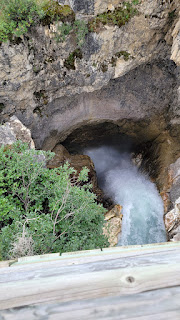
| These photos were taken from a bridge. Yes it is way far down there. I have a strap on the phone. I wonder how many phones are down there. |
 Marble Canyon, Kootenay Park: The falls are just under a mile round trip, some altitude gain but not bad. Developed trail, not wheelchair accessible. Dog friendly, toilets at the trail head. Other longer trails are available from this parking lot. No tour buses.
This may be my favorite hike of the entire trip. I will be back with my Geology Road Tours in hand. There is camping across the highway.
The rock here is limestone, shale and dolostone (a cousin to marble). There are iron deposits, rich red ochre (or ocher depending on who is spelling it). These red stone deposits were important to the First Nation people, and it was an important trade good for the preEuropean people.
There are deposits of the Burgess Shale. I blogged on this earlier in the Fossils chapter. Please note that fossil collecting is strictly prohibited. But there is joy in that you can see great hunks of the shale, and know that there are fossils in there somewhere.


 |
| Ochre |

 |
| This is at the top of the walk. |
 |
| Seven bridges that allow you to look straight down. |
 |
| 2003 a huge fire burned thru this area. You can watch the forest regenerate. |
 |
| There is much thought that this gorge was once a cave. Glacier scraping from above and water eroding from below. |

 |
| Burgess Shale |
 |
This is the deepest of the Slots in the Jasper area. At almost 50 meters deep (yeah, metric, get over it) the exposed walls are awesome. The trail is popular, but does not have the crush of the rampant tourists that Johnson Canyon has.
 |
| Just a few meters down from the sign there is a hunk of shale, Burgess Shale. and on it are 2 fossils. Right there, where people are walking on them. |
 |
| The Maligne Canyon is odd in that it is wider at the bottom than the top. This leads to the thought that this was once a cave, so the canyon grew from the bottom up. |
| If you have been reading the above notes about the rock caught in a hole then you know how these "pot holes" were formed. |


Comments